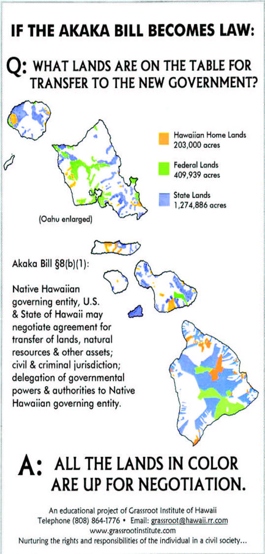
Transfer of land and natural resources. The sponsors of the bill have said that the approximately 200,000 acres of Hawaiian home lands plus the island of Kahoolawe would be given to the new government. But the bill specifies no limit on the amount of land to be transferred. In the past, OHA has demanded all the ceded lands (former government and crown lands), including those held by the U.S. for military bases, national parks and civil purposes.
Crazyquilt of separate enclaves. This map shows that, unlike typically contiguous Indian reservations, the proposed Native Hawaiian government’s territory would be a patchwork of separate sovereign enclaves.
Visualize the transmission lines. Indian tribes charge right-of-way fees for transmission lines across reservations or interrupt service. Look at the map above and visualize the transmission lines for electricity, telephone, gas, cable, water, sewer, storm drain, traffic lights and street lights. Every one that crosses the territory of the proposed Native Hawaiian government would be fair game for right-of-way charges or interruption of service.
Your utility bills. Imagine the effect on your home utility bill. You will pay more, not because you receive better service, but only because a sovereign Hawaiian government has the right to charge for or withhold transmission over its sovereign territory. Ditto for utilities to business, emergency services, airports, harbors, parks, military bases, national parks, the University of Hawaii and the summit of Mauna Kea.
